|
search place name
|
||
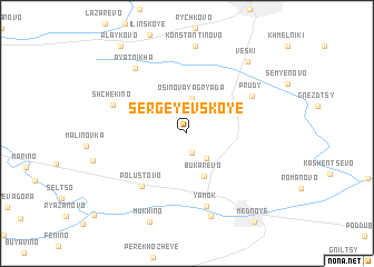
Sergeyevskoye (Tverskaya Oblast', Russia)Sergeyevskoye is a town in the Tverskaya Oblast' region of Russia. An overview map of the region around Sergeyevskoye is displayed below.
regional and 3d topo map of Sergeyevskoye, Russia ::
Sergeyevskoye airports ::
The nearest airport is KLD - Tver Migalovo, located 29.2 km south east of Sergeyevskoye.
Other airports nearby include VKO - Moscow Vnukovo (194.7 km south east), Nearby towns ::
Polupustosh' (2.0km south) //
Dmitrovskoye (2.8km south) //
Osinovaya Gryada (3.5km north) //
Bukarevo (4.4km south) //
Polustovo (5.9km south west) //
Yamok (7.3km south) //
Prudy (5.2km north east) //
Shchëkino (4.9km north west) //
Pyatnikha (7.1km north west) //
Porozhki (8.4km south) //
Konstantinovo (8.7km north) //
Veski (7.9km north east) //
Mukhino (9.1km south) //
Alaykovo (9.4km north) //
Mednoye (9.6km south) //
[all distances 'as the bird flies' and approximate] 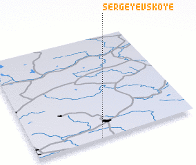 Places with similar names to Sergeyevskoye, Russia ::
// (( Sergiyevskoye )) (RU)
// Sergiyevskoye (RU)
// Sergeyevskaya (RU)
// Sergeyevskaya (RU)
// Sergeyevskaya (RU)
// Sergeyevskoye (RU)
// Sergeyevskoye (RU)
// Sergiyevskaya (RU)
// Sergiyevskaya (RU)
// Sergiyevskaya (RU)
Disclaimer :: Information on this page comes without warranty of any kind |
||
|
Where is Sergeyevskoye? Elevation and coordinates ::
Latitude (lat): 57°0'18"N Longitude (lon): 35°24'34"E
Elevation (approx.): 149m (map arrows pan, magnifying glasses zoom) |
||
|
Visiting Sergeyevskoye? Hotel/Accommodation ::
Book a hotel in Sergeyevskoye Travel Guide ::
Buy a travel guide for Russia rental cars ::
car rental offers GPS waypoint ::
download a GPX waypoint (PoI) of Sergeyevskoye for your GPS receiver
|
||