|
search place name
|
||
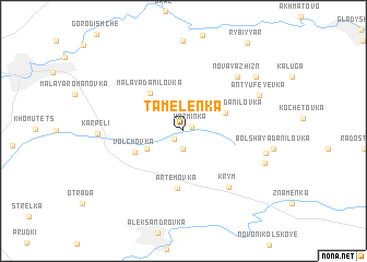
Tamelenka (Tambovskaya Oblast', Russia)Tamelenka is a town in the Tambovskaya Oblast' region of Russia. An overview map of the region around Tamelenka is displayed below.
regional and 3d topo map of Tamelenka, Russia ::
Tamelenka airports ::
The nearest airport is VOZ - Voronezh Chertovitskoye, located 117.5 km west of Tamelenka.
Nearby towns ::
Kaz'minka (0.6km north east) //
Zharkovo (1.0km south west) //
Kurabovka (1.9km south) //
Bol'shaya Romanovka (2.9km south west) //
Bol'shaya Danilovka (3.2km north east) //
Malaya Danilovka (4.3km north west) //
Volchovka (3.8km south west) //
Artëmovka (5.8km south) //
Krym (6.5km south east) //
Novaya Zhizn' (6.5km north east) //
Antyufeyevka (6.1km north east) //
Malaya Danilovka (5.7km south east) //
Karpeli (5.4km west) //
Plata (6.1km south east) //
Krasnaya Zvezda (7.2km north east) //
[all distances 'as the bird flies' and approximate]  Places with similar names to Tamelenka, Russia ::
// Dumalneg (PH)
// Diemling (AT)
// Damelang (DE)
// Deimling (DE)
// Demling (DE)
// Demling (DE)
// Tambalang (MY)
// Tumbling (US)
// Tumbalungu (CD)
// Diambo Lounga (CG)
Disclaimer :: Information on this page comes without warranty of any kind |
||
|
Where is Tamelenka? Elevation and coordinates ::
Latitude (lat): 52°2'0"N Longitude (lon): 40°54'0"E
Elevation (approx.): 159m (map arrows pan, magnifying glasses zoom) |
||
|
Visiting Tamelenka? Hotel/Accommodation ::
Book a hotel in Tamelenka Travel Guide ::
Buy a travel guide for Russia rental cars ::
car rental offers GPS waypoint ::
download a GPX waypoint (PoI) of Tamelenka for your GPS receiver
|
||