|
search place name
|
||
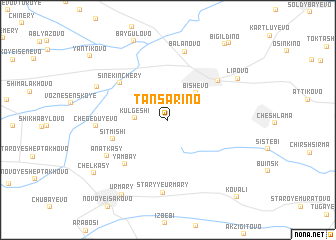
Tansarino (Chuvashiya, Russia)Tansarino is a town in the Chuvashiya region of Russia. An overview map of the region around Tansarino is displayed below.
regional and 3d topo map of Tansarino, Russia ::
Tansarino airports ::
The nearest airport is KZN - Kazan, located 82.9 km east of Tansarino.
Nearby towns ::
Kul'geshi (2.1km west) //
Bishevo (3.5km north east) //
Sitmishi (4.1km south west) //
Sine-Kinchery (5.1km north west) //
Yambay (5.6km south west) //
Yemetkino (5.4km north east) //
Balanovo (7.7km north) //
Anatkasy (5.6km south west) //
Chegeduyevo (4.6km west) //
Staryye Urmary (8.1km south) //
Staroye Yansitovo (5.8km north west) //
Lipovo (6.4km north east) //
Baygulovo (9.1km north) //
Urmary (8.9km south) //
Chelkasy (7.6km south west) //
Bigil'dino (9.2km north east) //
Ilebary (9.4km north east) //
Yantikovo (8.6km north west) //
Kovali (9.6km south east) //
[all distances 'as the bird flies' and approximate]  Places with similar names to Tansarino, Russia ::
// Tinzourine (MA)
// Dans Run (US)
Disclaimer :: Information on this page comes without warranty of any kind |
||
|
Where is Tansarino? Elevation and coordinates ::
Latitude (lat): 55°45'23"N Longitude (lon): 47°59'19"E
Elevation (approx.): 138m (map arrows pan, magnifying glasses zoom) |
||
|
Visiting Tansarino? Hotel/Accommodation ::
Book a hotel in Tansarino Travel Guide ::
Buy a travel guide for Russia rental cars ::
car rental offers GPS waypoint ::
download a GPX waypoint (PoI) of Tansarino for your GPS receiver
|
||