|
search place name
|
||
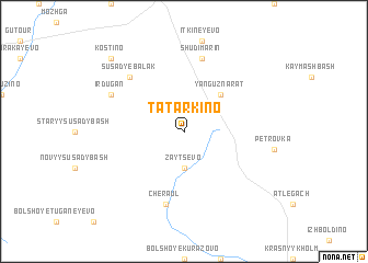
Tatarkino (Bashkortostan, Russia)Tatarkino is a town in the Bashkortostan region of Russia. An overview map of the region around Tatarkino is displayed below.
regional and 3d topo map of Tatarkino, Russia ::
Tatarkino airports ::
The nearest airport is UFA - Ufa, located 185.0 km south of Tatarkino.
Other airports nearby include PEE - Perm Bolshoye Savino (208.7 km north), Nearby towns ::
Zaytsevo (3.7km south) //
Yanguznarat (4.2km north east) //
Cheraul (7.5km south) //
Shudi-Marin (7.5km north) //
Susady-Ebalak (6.4km north west) //
Irdugan (5.5km north west) //
Kostino (8.5km north west) //
[all distances 'as the bird flies' and approximate] 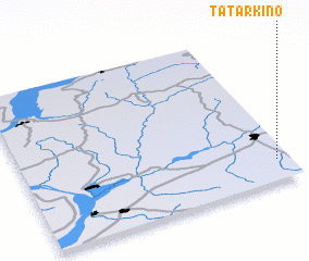 Places with similar names to Tatarkino, Russia ::
// Tatarkino (RU)
// Tetërkino (RU)
// Tutrakan (BG)
// Deh Torkān (IR)
// Tūtūrqān (IR)
// Tatarikan (PH)
// Tatarikan (PH)
// Deh Torkān (AF)
// Tătărăuca Nouă (MD)
Disclaimer :: Information on this page comes without warranty of any kind |
||
|
Where is Tatarkino? Elevation and coordinates ::
Latitude (lat): 56°8'0"N Longitude (lon): 54°57'0"E
Elevation (approx.): 188m (map arrows pan, magnifying glasses zoom) |
||
|
Visiting Tatarkino? Hotel/Accommodation ::
Book a hotel in Tatarkino Travel Guide ::
Buy a travel guide for Russia rental cars ::
car rental offers GPS waypoint ::
download a GPX waypoint (PoI) of Tatarkino for your GPS receiver
|
||