|
search place name
|
||
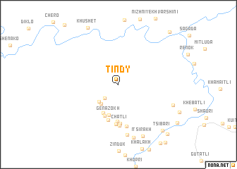
(( Tindy )) (Dagestan, Russia)(( Tindy )) is a town in the Dagestan region of Russia. An overview map of the region around (( Tindy )) is displayed below.
regional and 3d topo map of (( Tindy )), Russia ::
(( Tindy )) airports ::
The nearest airport is MCX - Makhachkala Uytash, located 160.6 km east of (( Tindy )).
Nearby towns ::
Makhalotli (2.7km south west) //
Terutli (3.6km south west) //
(( Kiyatl' )) (3.6km south west) //
Genazokh (5.0km south) //
Tsokhok (4.9km south) //
Udok (5.3km south) //
Shiya (5.8km south) //
Asakh (5.9km south) //
Chatli (6.2km south) //
Khora (6.3km south) //
Ikha (6.5km south) //
Akdy (6.7km south) //
Retlob (8.1km south) //
Chalyakh (8.6km south) //
Itsirakh (8.7km south) //
Galatli (7.2km south east) //
Tsibari (8.9km south east) //
Takkho (9.8km south east) //
Metrada (10.2km north east) //
[all distances 'as the bird flies' and approximate] 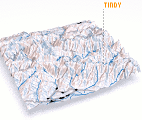 Places with similar names to (( Tindy )), Russia ::
Disclaimer :: Information on this page comes without warranty of any kind |
||
|
Where is (( Tindy ))? Elevation and coordinates ::
Latitude (lat): 42°19'0"N Longitude (lon): 45°49'0"E
Elevation (approx.): 2577m (map arrows pan, magnifying glasses zoom) |
||
|
Visiting (( Tindy ))? Hotel/Accommodation ::
Book a hotel in (( Tindy )) Travel Guide ::
Buy a travel guide for Russia rental cars ::
car rental offers GPS waypoint ::
download a GPX waypoint (PoI) of (( Tindy )) for your GPS receiver
|
||