|
search place name
|
||
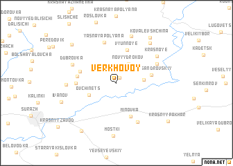
Verkhovoy (Bryanskaya Oblast', Russia)Verkhovoy is a town in the Bryanskaya Oblast' region of Russia. An overview map of the region around Verkhovoy is displayed below.
regional and 3d topo map of Verkhovoy, Russia ::
Verkhovoy airports ::
The nearest airport is BZK - Bryansk, located 112.2 km east of Verkhovoy.
Other airports nearby include GME - Gomel (117.6 km south west), Nearby towns ::
Krasnyy Bor (0.9km north) //
Novyy Drokov (3.2km north) //
Tëplyy (2.7km east) //
Ovchinets (3.3km south west) //
V'yunnoye (5.4km north) //
Aleksandrovskiy (3.6km east) //
Minovka (5.6km south) //
Vasenkov (4.0km north west) //
Sofiyenkov (4.0km west) //
Putilin (3.9km west) //
Yasnaya Polyana (6.7km north) //
Lyalichi (6.6km south) //
Staryy Drokov (5.0km north east) //
Dubrovka (5.2km north west) //
Krasnoye (5.8km north east) //
Vysokoselishche (7.7km north) //
Petrovskiy (4.9km west) //
Gordyy (7.2km north east) //
Mostki (8.6km south) //
Kovalevshchina (8.0km north east) //
Narost' (7.5km north west) //
Kamensk (8.5km south west) //
Krasnyy Pakhar' (7.9km south east) //
[all distances 'as the bird flies' and approximate] 
Disclaimer :: Information on this page comes without warranty of any kind |
||
|
Where is Verkhovoy? Elevation and coordinates ::
Latitude (lat): 53°3'48"N Longitude (lon): 32°31'6"E
Elevation (approx.): 184m (map arrows pan, magnifying glasses zoom) |
||
|
Visiting Verkhovoy? Hotel/Accommodation ::
Book a hotel in Verkhovoy Travel Guide ::
Buy a travel guide for Russia rental cars ::
car rental offers GPS waypoint ::
download a GPX waypoint (PoI) of Verkhovoy for your GPS receiver
|
||