|
search place name
|
||
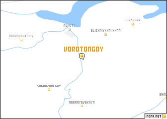
Vorot-Ongoy (Ust'-Ordynskiy Buryatskiy Avtonomnyy Okrug, Russia)Vorot-Ongoy is a town in the Ust'-Ordynskiy Buryatskiy Avtonomnyy Okrug region of Russia. An overview map of the region around Vorot-Ongoy is displayed below.
regional and 3d topo map of Vorot-Ongoy, Russia ::
Vorot-Ongoy airports ::
The nearest airport is IKT - Irkutsk, located 187.1 km south east of Vorot-Ongoy.
Nearby towns ::
Nukuty (7.0km north) //
Blizhniy Khamkhar (6.4km north east) //
Sagan-Zhalgay (8.2km south west) //
[all distances 'as the bird flies' and approximate] 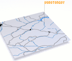 Places with similar names to Vorot-Ongoy, Russia ::
// Vorotynka (RU)
// Freudeneck (DE)
// Freudenegg (DE)
// Frieding (DE)
// Frieding (DE)
// Vorading (DE)
// Fordonek (PL)
// Vratnica (BA)
// Fortunago (IT)
// Vratnica (MK)
Disclaimer :: Information on this page comes without warranty of any kind |
||
|
Where is Vorot-Ongoy? Elevation and coordinates ::
Latitude (lat): 53°39'42"N Longitude (lon): 102°49'56"E
Elevation (approx.): 413m (map arrows pan, magnifying glasses zoom) |
||
|
Visiting Vorot-Ongoy? Hotel/Accommodation ::
Book a hotel in Vorot-Ongoy Travel Guide ::
Buy a travel guide for Russia rental cars ::
car rental offers GPS waypoint ::
download a GPX waypoint (PoI) of Vorot-Ongoy for your GPS receiver
|
||