|
search place name
|
||
Bolivar (Alabama, United States - USA)Bolivar is a town in the Alabama region of United States - USA. An overview map of the region around Bolivar is displayed below.
regional and 3d topo map of Bolivar, United States - USA ::

Bolivar airports ::
The nearest airport is CHA - Chattanooga Lovell Fld, located 53.9 km east of Bolivar.
Other airports nearby include HUA - Redstone Aaf (87.2 km west), ANB - Anniston Metro (147.2 km south), BNA - Nashville Intl (157.4 km north west), MGE - Marietta Dobbins Arb (Atlanta Nas) (160.1 km south east), Nearby towns ::
Widows Creek Station (1.9km north east) //
Mount Carmel (2.6km north) //
Cumberland Junction (3.4km north) //
Edgefield (3.2km west) //
Coopers Mill (4.5km north west) //
Summer Bluff (5.1km north) //
Rocky Springs (5.3km north) //
Haynes Crossing (5.1km south west) //
Cameronsville (5.5km south east) //
New Town (5.9km south west) //
Montague (6.7km north) //
Bridgeport (6.7km north east) //
Pinder Hill (7.6km south west) //
Battery Hill (7.5km north east) //
Stevenson (7.7km south west) //
[all distances 'as the bird flies' and approximate] 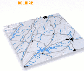 Places with similar names to Bolivar, United States - USA ::
Disclaimer :: Information on this page comes without warranty of any kind |
||
|
Where is Bolivar? Elevation and coordinates ::
Latitude (lat): 34°54'48"N Longitude (lon): 85°46'30"W
Elevation (approx.): 189m (map arrows pan, magnifying glasses zoom) |
||
|
Visiting Bolivar? Hotel/Accommodation ::
Book a hotel in Bolivar Travel Guide ::
rental cars ::
car rental offers GPS waypoint ::
download a GPX waypoint (PoI) of Bolivar for your GPS receiver
|
||