|
search place name
|
||
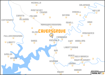
Cavers Grove (Alabama, United States - USA)Cavers Grove is a town in the Alabama region of United States - USA. An overview map of the region around Cavers Grove is displayed below.
regional and 3d topo map of Cavers Grove, United States - USA ::
Cavers Grove airports ::
The nearest airport is ANB - Anniston Metro, located 40.6 km north west of Cavers Grove.
Other airports nearby include ATL - Hartsfield Jackson Atlanta Intl (102.3 km east), MGE - Marietta Dobbins Arb (Atlanta Nas) (107.3 km north east), BHM - Birmingham Intl (119.0 km west), LSF - Fort Benning Lawson Aaf (125.9 km south), Nearby towns ::
Rockdale (1.9km south) //
Union (3.1km north) //
Cambridge (2.9km east) //
Morrison Crossroad (3.8km north) //
Ava (5.5km south) //
Milner (5.2km west) //
Swagg (5.8km west) //
Curt (5.9km east) //
Jordan Chapel (7.2km north) //
Newell (6.9km north east) //
Liberty Grove (7.1km south east) //
Foster Crossroad (7.0km north west) //
Smyrna (8.3km north east) //
Cedron (8.6km north) //
Folsom (8.9km north west) //
Peace (9.2km south east) //
New Hope (9.6km south east) //
Pine Hill (11.1km north east) //
[all distances 'as the bird flies' and approximate] 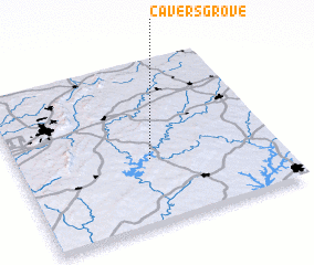 Places with similar names to Cavers Grove, United States - USA :: Disclaimer :: Information on this page comes without warranty of any kind |
||
|
Where is Cavers Grove? Elevation and coordinates ::
Latitude (lat): 33°23'31"N Longitude (lon): 85°29'23"W
Elevation (approx.): 308m (map arrows pan, magnifying glasses zoom) |
||
|
Visiting Cavers Grove? Hotel/Accommodation ::
Book a hotel in Cavers Grove Travel Guide ::
rental cars ::
car rental offers GPS waypoint ::
download a GPX waypoint (PoI) of Cavers Grove for your GPS receiver
|
||