|
search place name
|
||
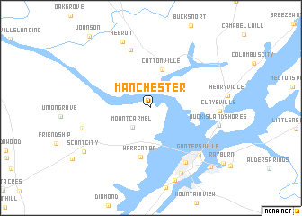
Manchester (Alabama, United States - USA)Manchester is a town in the Alabama region of United States - USA. An overview map of the region around Manchester is displayed below.
regional and 3d topo map of Manchester, United States - USA ::
Manchester airports ::
The nearest airport is HUA - Redstone Aaf, located 42.8 km north west of Manchester.
Other airports nearby include BHM - Birmingham Intl (101.3 km south), ANB - Anniston Metro (101.9 km south east), CHA - Chattanooga Lovell Fld (125.6 km north east), MGE - Marietta Dobbins Arb (Atlanta Nas) (177.6 km east), Nearby towns ::
Mount Carmel (3.1km south west) //
Cottonville (4.8km north) //
Warrenton (6.1km south) //
Cushion (7.5km north) //
Southtown (7.7km south east) //
Guntersville (7.7km south east) //
Claysville (7.0km east) //
Buck Island Shores (7.3km east) //
Neighbors Mill (7.4km west) //
Mill Village (8.7km south) //
Hebron (8.8km north) //
Scant City (8.8km south west) //
Wyeth City (9.5km south east) //
Johnson (10.9km north west) //
[all distances 'as the bird flies' and approximate]  Places with similar names to Manchester, United States - USA ::
// Manchester (US)
// Manchester (US)
// Manchester (US)
// Manchester (US)
// Manchester (US)
// Manchester (US)
// Manchester (US)
// Manchester (US)
// Manchester (US)
// Manychstroy (RU)
Disclaimer :: Information on this page comes without warranty of any kind |
||
|
Where is Manchester? Elevation and coordinates ::
Latitude (lat): 34°24'40"N Longitude (lon): 86°20'54"W
Elevation (approx.): 225m (map arrows pan, magnifying glasses zoom) |
||
|
Visiting Manchester? Hotel/Accommodation ::
Book a hotel in Manchester Travel Guide ::
rental cars ::
car rental offers GPS waypoint ::
download a GPX waypoint (PoI) of Manchester for your GPS receiver
|
||