|
search place name
|
||
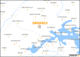
Sand Rock (Alabama, United States - USA)Sand Rock is a town in the Alabama region of United States - USA. An overview map of the region around Sand Rock is displayed below.
regional and 3d topo map of Sand Rock, United States - USA ::
Sand Rock airports ::
The nearest airport is ANB - Anniston Metro, located 73.1 km south of Sand Rock.
Other airports nearby include HUA - Redstone Aaf (97.1 km north west), CHA - Chattanooga Lovell Fld (102.0 km north east), BHM - Birmingham Intl (118.3 km south west), MGE - Marietta Dobbins Arb (Atlanta Nas) (121.2 km east), Nearby towns ::
Ewing (4.5km south) //
Powell (5.2km north) //
Bristow (5.3km south) //
Blue Pond (4.5km east) //
Richardson (5.3km south east) //
Mount Vernon (5.8km north) //
Hopewell (5.9km south east) //
Leesburg (7.0km south) //
Leonard (6.9km south west) //
Weiss Dam (8.0km south) //
Mackey (8.1km south) //
Loveless (8.4km north) //
McGhee (9.0km south) //
Bay Springs (8.9km south east) //
Billy Goat Hill (8.7km south east) //
Portersville (9.9km north west) //
[all distances 'as the bird flies' and approximate]  Places with similar names to Sand Rock, United States - USA ::
// Santa Erica (BR)
// Cienia Druga (PL)
// Santrač (BA)
// Santrač (BA)
// Santu Rokku (MT)
// Şintereag (RO)
// Şendurak (TR)
// Santarka (UA)
// Sindārōk (IQ)
// Sandraka (MG)
Disclaimer :: Information on this page comes without warranty of any kind |
||
|
Where is Sand Rock? Elevation and coordinates ::
Latitude (lat): 34°14'34"N Longitude (lon): 85°46'7"W
Elevation (approx.): 278m (map arrows pan, magnifying glasses zoom) |
||
|
Visiting Sand Rock? Hotel/Accommodation ::
Book a hotel in Sand Rock Travel Guide ::
rental cars ::
car rental offers GPS waypoint ::
download a GPX waypoint (PoI) of Sand Rock for your GPS receiver
|
||