|
search place name
|
||
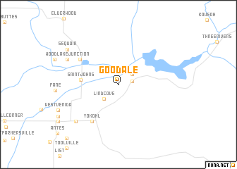
Goodale (California, United States - USA)Goodale is a town in the California region of United States - USA. An overview map of the region around Goodale is displayed below.
regional and 3d topo map of Goodale, United States - USA ::
Goodale airports ::
The nearest airport is FAT - Fresno Yosemite Intl, located 74.8 km north west of Goodale.
Other airports nearby include BFL - Bakersfield Meadows Fld (104.8 km south), MER - Merced Castle (175.7 km north west), EDW - Edwards Afb (194.2 km south east), PMD - Palmdale Rgnl Usaf Plt 42 (212.6 km south east), Nearby towns ::
Lemoncove (1.8km east) //
Citro (2.4km north east) //
Lindcove (2.9km south west) //
Saint Johns (4.9km west) //
Yokohl (6.8km south west) //
Woodlake (6.3km north west) //
Merryman (8.0km south west) //
Woodlake Junction (7.6km north west) //
Sequoia (8.5km north west) //
Rocky Hill (10.8km south west) //
[all distances 'as the bird flies' and approximate] 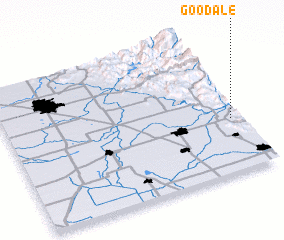 Places with similar names to Goodale, United States - USA ::
Disclaimer :: Information on this page comes without warranty of any kind |
||
|
Where is Goodale? Elevation and coordinates ::
Latitude (lat): 36°22'41"N Longitude (lon): 119°2'36"W
Elevation (approx.): 148m (map arrows pan, magnifying glasses zoom) |
||
|
Visiting Goodale? Hotel/Accommodation ::
Book a hotel in Goodale Travel Guide ::
rental cars ::
car rental offers GPS waypoint ::
download a GPX waypoint (PoI) of Goodale for your GPS receiver
|
||