|
search place name
|
||
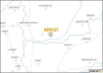
Honcut (California, United States - USA)Honcut is a town in the California region of United States - USA. An overview map of the region around Honcut is displayed below.
regional and 3d topo map of Honcut, United States - USA ::
Honcut airports ::
The nearest airport is BAB - Marysville Beale Afb, located 23.0 km south of Honcut.
Other airports nearby include SMF - Sacramento Intl (70.5 km south), MCC - Sacramento Mc Clellan Afld (74.3 km south), SAC - Sacramento Executive (90.7 km south), RIU - Rancho Murieta (100.7 km south), Nearby towns ::
Craig (2.8km west) //
Iowa City (6.4km south east) //
Robinsons Corner (7.5km north west) //
[all distances 'as the bird flies' and approximate]  Places with similar names to Honcut, United States - USA ::
// Hanigad (PH)
// Whangateau (NZ)
// Whenuakite (NZ)
// Honeycutt (US)
// Honeycutt (US)
// Huongodaa (ID)
// Hengoda (LK)
// Hunugoda (LK)
// Hunuketa (LK)
// Hangata (ZM)
Disclaimer :: Information on this page comes without warranty of any kind |
||
|
Where is Honcut? Elevation and coordinates ::
Latitude (lat): 39°19'45"N Longitude (lon): 121°31'58"W
Elevation (approx.): 32m (map arrows pan, magnifying glasses zoom) |
||
|
Visiting Honcut? Hotel/Accommodation ::
Book a hotel in Honcut Travel Guide ::
rental cars ::
car rental offers GPS waypoint ::
download a GPX waypoint (PoI) of Honcut for your GPS receiver
|
||