|
search place name
|
||
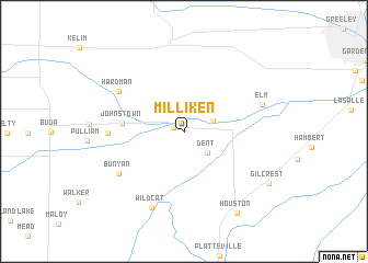
Milliken (Colorado, United States - USA)Milliken is a town in the Colorado region of United States - USA. An overview map of the region around Milliken is displayed below.
regional and 3d topo map of Milliken, United States - USA ::
Milliken airports ::
The nearest airport is DEN - Denver Intl, located 54.2 km south of Milliken.
Other airports nearby include BKF - Buckley Afb (70.3 km south), CYS - Cheyenne Rgnl Jerry Olson Fld (91.8 km north), COS - City Of Colorado Springs Muni (169.7 km south), Nearby towns ::
Hillsboro (0.9km north west) //
Adna (2.5km north east) //
Dent (2.8km south east) //
Johnstown (4.9km west) //
Hardman (6.5km north west) //
Clark (6.0km west) //
Bunyan (6.7km south west) //
Elm (6.6km north east) //
Wildcat (8.2km south) //
Houston (9.3km south east) //
Gilcrest (8.4km south east) //
[all distances 'as the bird flies' and approximate]  Places with similar names to Milliken, United States - USA ::
Disclaimer :: Information on this page comes without warranty of any kind |
||
|
Where is Milliken? Elevation and coordinates ::
Latitude (lat): 40°19'46"N Longitude (lon): 104°51'17"W
Elevation (approx.): 1453m (map arrows pan, magnifying glasses zoom) |
||
|
Visiting Milliken? Hotel/Accommodation ::
Book a hotel in Milliken Travel Guide ::
rental cars ::
car rental offers GPS waypoint ::
download a GPX waypoint (PoI) of Milliken for your GPS receiver
|
||