|
search place name
|
||
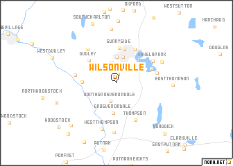
Wilsonville (Connecticut, United States - USA)Wilsonville is a town in the Connecticut region of United States - USA. An overview map of the region around Wilsonville is displayed below.
regional and 3d topo map of Wilsonville, United States - USA ::
Wilsonville airports ::
The nearest airport is PVD - Providence Theodore Francis Green State, located 49.9 km south east of Wilsonville.
Other airports nearby include CEF - Chicopee Falls Westover Arb Metropolitan (57.0 km west), BDL - Windsor Locks Bradley Intl (66.2 km west), HFD - Hartford Brainard (70.0 km south west), BED - Bedford Laurence G Hanscom Fld (71.1 km north east), Nearby towns ::
Perryville (1.4km north) //
Fennerville (2.9km north) //
North Grosvenor Dale (3.0km south) //
Chaseville (3.3km north) //
Merino Village (4.2km north) //
Webster (4.3km north) //
Grosvenor Dale (4.9km south) //
Fabyan (4.1km west) //
North Village (5.5km north) //
Sunnyside (5.6km north) //
Dudley (4.9km north west) //
Loveland (4.7km north east) //
East Village (5.8km north) //
Thompson (6.4km south) //
Colonial Park (5.1km east) //
Quinebaug (5.1km west) //
Wawela Park (5.6km north east) //
Cardinal Heights (6.4km north west) //
West Thompson (7.7km south) //
Mechanicsville (8.0km south) //
Lakeview Heights (6.4km north east) //
Grand View Estates (8.7km north) //
Roseland Park (8.8km south west) //
South Woodstock (10.0km south west) //
Quaddick (10.0km south east) //
[all distances 'as the bird flies' and approximate]  Places with similar names to Wilsonville, United States - USA ::
// Wilsonville (US)
// Wilsonville (US)
// Wilsonville (US)
// Wilsonville (US)
// Wilsonville (US)
// Wilsonville (US)
// Wilsonville (US)
// Wilsonville (US)
// Wilsonville (US)
// Wilsonville (US)
Disclaimer :: Information on this page comes without warranty of any kind |
||
|
Where is Wilsonville? Elevation and coordinates ::
Latitude (lat): 42°0'44"N Longitude (lon): 71°53'26"W
Elevation (approx.): 122m (map arrows pan, magnifying glasses zoom) |
||
|
Visiting Wilsonville? Hotel/Accommodation ::
Book a hotel in Wilsonville Travel Guide ::
rental cars ::
car rental offers GPS waypoint ::
download a GPX waypoint (PoI) of Wilsonville for your GPS receiver
|
||