|
search place name
|
||
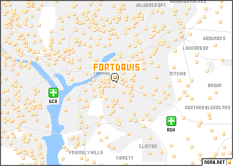
Fort Davis (District of Columbia, United States - USA)Fort Davis is a town in the District of Columbia region of United States - USA. An overview map of the region around Fort Davis is displayed below.
regional and 3d topo map of Fort Davis, United States - USA ::
Fort Davis airports ::
The nearest airport is DCA - Ronald Reagan Washington Natl, located 8.1 km west of Fort Davis.
Other airports nearby include ADW - Camp Springs Andrews Afb (Washington Dc Naf) (9.3 km south east), BWI - Baltimore Washington Intl (41.9 km north east), IAD - Washington Dulles Intl (45.0 km west), NHK - Patuxent River Nas (79.5 km south east), Nearby towns ::
Dupont Park (0.6km north west) //
Fairfax Village (0.7km south west) //
Dillon Park (0.8km east) //
Fort Dupont (0.9km north east) //
Pennsylvania Avenue Hights (1.0km west) //
Hillcrest (1.2km south west) //
Penn Branch (1.2km north west) //
Boulevard Heights (1.2km east) //
Bradbury Heights (1.3km east) //
Arnold Heights (1.7km south east) //
West Over View (1.5km west) //
Benning Heights (1.9km north east) //
Good Hope (1.6km west) //
Twining (1.8km west) //
Randle Highlands (1.8km west) //
Dupont Heights (1.9km east) //
Greenway (2.4km north) //
Hillside (2.0km east) //
Naylor Gardens (2.1km south west) //
Bradbury Park (2.1km south east) //
Suitland Manor (2.3km south east) //
Knox Hill Dwellings (2.3km south west) //
Woodland (2.2km west) //
Silver Hill (2.8km south) //
Coral Hills (2.2km east) //
Garfield Heights (2.4km south west) //
Colebrooke (2.9km south) //
Marshall Heights (2.7km north east) //
Capitol View (2.8km north east) //
[all distances 'as the bird flies' and approximate] 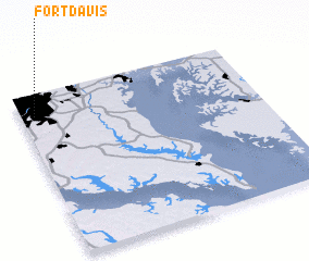 Places with similar names to Fort Davis, United States - USA ::
Disclaimer :: Information on this page comes without warranty of any kind |
||
|
Where is Fort Davis? Elevation and coordinates ::
Latitude (lat): 38°52'0"N Longitude (lon): 76°56'47"W
Elevation (approx.): 80m (map arrows pan, magnifying glasses zoom) |
||
|
Visiting Fort Davis? Hotel/Accommodation ::
Book a hotel in Fort Davis Travel Guide ::
rental cars ::
car rental offers GPS waypoint ::
download a GPX waypoint (PoI) of Fort Davis for your GPS receiver
|
||