|
search place name
|
||
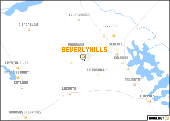
Beverly Hills (Florida, United States - USA)Beverly Hills is a town in the Florida region of United States - USA. An overview map of the region around Beverly Hills is displayed below.
regional and 3d topo map of Beverly Hills, United States - USA ::
Beverly Hills airports ::
The nearest airport is GNV - Gainesville Rgnl, located 87.6 km north of Beverly Hills.
Other airports nearby include TPA - Tampa Intl (104.6 km south), PIE - St. Petersburg St Petersburg Clearwater Intl (113.8 km south), MCF - Tampa Macdill Afb (118.4 km south), MCO - Orlando Intl (124.6 km south east), Nearby towns ::
Pine Ridge (2.8km north west) //
Black Diamond (2.7km west) //
Citrus Hills (4.0km south east) //
Holder (6.7km north east) //
Felicia (6.3km east) //
Seacoll (6.7km east) //
Lecanto (7.8km south) //
Calphos (7.2km east) //
Bevens (7.8km north east) //
Harrison (8.3km north east) //
[all distances 'as the bird flies' and approximate] 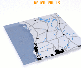 Places with similar names to Beverly Hills, United States - USA ::
// Beverly Hills (US)
// Beverly Hills (US)
// Beverly Hills (US)
// Beverly Hills (US)
// Beverly Hills (US)
// Beverly Hills (US)
// Beverly Hills (US)
// Beverly Hills (US)
// Beverly Hills (US)
// Beverly Hills (US)
Disclaimer :: Information on this page comes without warranty of any kind |
||
|
Where is Beverly Hills? Elevation and coordinates ::
Latitude (lat): 28°55'0"N Longitude (lon): 82°27'30"W
Elevation (approx.): 37m (map arrows pan, magnifying glasses zoom) |
||
|
Visiting Beverly Hills? Hotel/Accommodation ::
Book a hotel in Beverly Hills Travel Guide ::
rental cars ::
car rental offers GPS waypoint ::
download a GPX waypoint (PoI) of Beverly Hills for your GPS receiver
|
||