|
search place name
|
||
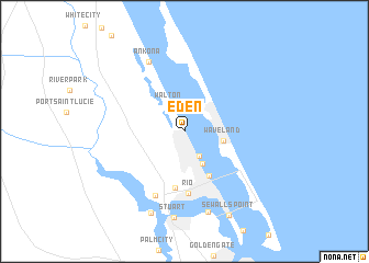
Eden (Florida, United States - USA)Eden is a town in the Florida region of United States - USA. An overview map of the region around Eden is displayed below.
regional and 3d topo map of Eden, United States - USA ::
Eden airports ::
The nearest airport is VRB - Vero Beach Muni, located 45.4 km north of Eden.
Other airports nearby include PBI - West Palm Beach Palm Beach Intl (67.3 km south), MLB - Melbourne Intl (99.8 km north west), COF - Coco Beach Patrick Afb (112.2 km north), FLL - Fort Lauderdale Hollywood Intl (133.7 km south), Nearby towns ::
Jensen Beach (2.8km south east) //
Walton (2.9km north west) //
Skyline Heights (3.6km south east) //
Waveland (3.7km east) //
Ocean Breeze Park (5.0km south east) //
Palm Lake Park (5.8km south) //
Rio (6.4km south) //
North River Shores (7.1km south) //
Ankona (7.8km north west) //
Snug Harbor (8.5km south) //
Stuart (8.9km south) //
Lighthouse Point (8.8km south) //
Sewalls Point (9.5km south east) //
[all distances 'as the bird flies' and approximate] 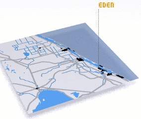 Places with similar names to Eden, United States - USA ::
Disclaimer :: Information on this page comes without warranty of any kind |
||
|
Where is Eden? Elevation and coordinates ::
Latitude (lat): 27°16'35"N Longitude (lon): 80°14'35"W
Elevation (approx.): 12m (map arrows pan, magnifying glasses zoom) |
||
|
Visiting Eden? Hotel/Accommodation ::
Book a hotel in Eden Travel Guide ::
rental cars ::
car rental offers GPS waypoint ::
download a GPX waypoint (PoI) of Eden for your GPS receiver
|
||