|
search place name
|
||
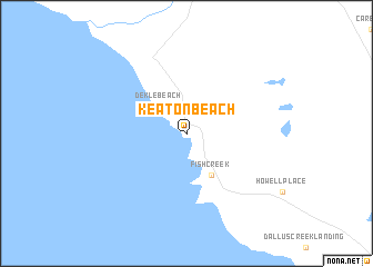
Keaton Beach (Florida, United States - USA)Keaton Beach is a town in the Florida region of United States - USA. An overview map of the region around Keaton Beach is displayed below.
regional and 3d topo map of Keaton Beach, United States - USA ::
Keaton Beach airports ::
The nearest airport is TLH - Tallahassee Rgnl, located 96.6 km north west of Keaton Beach.
Other airports nearby include GNV - Gainesville Rgnl (128.8 km east), VAD - Valdosta Moody Afb (132.5 km north), NIP - Jacksonville Nas (190.2 km east), PAM - Panama City Tyndall Afb (193.1 km west), Nearby towns ::
Dekle Beach (3.6km north west) //
Fish Creek (4.8km south east) //
[all distances 'as the bird flies' and approximate]  Places with similar names to Keaton Beach, United States - USA ::
// Güttenbach (AT)
// Kittenbach (AT)
// Göttenbach (DE)
// Guttenbach (DE)
// Kautenbach (DE)
// Kettenbach (DE)
// Kettenbach (DE)
// Kautenbach (LU)
// Kot Nabi Shāh (PK)
// Kadenbach (DE)
Disclaimer :: Information on this page comes without warranty of any kind |
||
|
Where is Keaton Beach? Elevation and coordinates ::
Latitude (lat): 29°49'27"N Longitude (lon): 83°35'42"W
Elevation (approx.): -32768m (map arrows pan, magnifying glasses zoom) |
||
|
Visiting Keaton Beach? Hotel/Accommodation ::
Book a hotel in Keaton Beach Travel Guide ::
rental cars ::
car rental offers GPS waypoint ::
download a GPX waypoint (PoI) of Keaton Beach for your GPS receiver
|
||