|
search place name
|
||
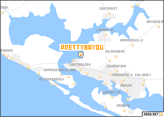
Pretty Bayou (Florida, United States - USA)Pretty Bayou is a town in the Florida region of United States - USA. An overview map of the region around Pretty Bayou is displayed below.
regional and 3d topo map of Pretty Bayou, United States - USA ::
Pretty Bayou airports ::
The nearest airport is PAM - Panama City Tyndall Afb, located 18.3 km south east of Pretty Bayou.
Other airports nearby include VPS - Valparaiso Eglin Afb (85.8 km west), CEW - Crestview Bob Sikes (102.2 km north west), DHN - Dothan Rgnl (126.9 km north), TLH - Tallahassee Rgnl (131.4 km east), Nearby towns ::
Bayview (1.6km west) //
Saint Andrew (2.5km south) //
Baker (3.6km south) //
Magnolia Beach (5.0km south west) //
Panama City (5.5km south east) //
Delwood Beach (6.0km south) //
Upper Grand Lagoon (5.6km south west) //
Dirego Park (5.5km east) //
Glenwood (6.8km south east) //
Lynn Haven (7.2km north east) //
Cove (7.3km south east) //
Hiland Park (6.7km east) //
Lower Grand Lagoon (7.8km south west) //
Cedar Grove (7.4km east) //
Millville (8.1km south east) //
Biltmore Beach (8.3km south west) //
[all distances 'as the bird flies' and approximate] 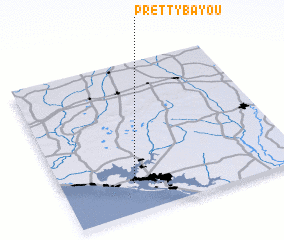 Places with similar names to Pretty Bayou, United States - USA :: Disclaimer :: Information on this page comes without warranty of any kind |
||
|
Where is Pretty Bayou? Elevation and coordinates ::
Latitude (lat): 30°11'47"N Longitude (lon): 85°41'48"W
Elevation (approx.): 7m (map arrows pan, magnifying glasses zoom) |
||
|
Visiting Pretty Bayou? Hotel/Accommodation ::
Book a hotel in Pretty Bayou Travel Guide ::
rental cars ::
car rental offers GPS waypoint ::
download a GPX waypoint (PoI) of Pretty Bayou for your GPS receiver
|
||