|
search place name
|
||
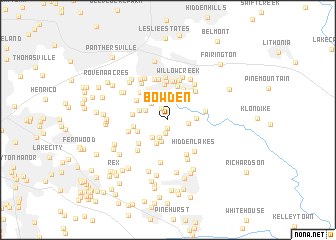
Bowden (Georgia, United States - USA)Bowden is a town in the Georgia region of United States - USA. An overview map of the region around Bowden is displayed below.
regional and 3d topo map of Bowden, United States - USA ::
Bowden airports ::
The nearest airport is ATL - Hartsfield Jackson Atlanta Intl, located 19.7 km west of Bowden.
Other airports nearby include MGE - Marietta Dobbins Arb (Atlanta Nas) (40.9 km north west), MCN - Macon Middle Georgia Rgnl (118.1 km south east), WRB - Macon Robins Afb (125.7 km south east), ANB - Anniston Metro (152.5 km west), Nearby towns ::
Del Pines (0.9km south) //
Royal Oaks (1.5km north west) //
Scarbrough Cross Roads (1.6km south) //
Strawberry Hills (2.1km south west) //
Brookfield Woods (1.9km east) //
Autumn Chase (2.4km south) //
Panola Woods (2.4km south west) //
Chimney Ridge (2.4km north west) //
Cherrywood (2.4km north west) //
Fairfield Glen (2.8km south) //
Raiders Ridge (2.9km north east) //
Dogwood Hills (3.1km north) //
Panola (2.7km east) //
East Glen (2.8km west) //
Cumberland Green (3.3km north east) //
Creek Cove (3.1km south west) //
Stonehenge (3.7km north east) //
Brook Glen (3.6km north west) //
Chapel Hill (3.9km north) //
Harry Pooles Mobile Home Park (3.3km west) //
Lincolndale (3.4km west) //
Chapel Mill (4.0km north) //
River Run (3.7km north west) //
Fairview Station (3.8km south west) //
Sheffield Woods (4.0km north east) //
Miners Creek (3.6km east) //
Dogwood Forest (4.3km north) //
Kings Row (4.3km north) //
Fairview Manor (4.2km south east) //
[all distances 'as the bird flies' and approximate]  Places with similar names to Bowden, United States - USA ::
Disclaimer :: Information on this page comes without warranty of any kind |
||
|
Where is Bowden? Elevation and coordinates ::
Latitude (lat): 33°38'40"N Longitude (lon): 84°12'59"W
Elevation (approx.): 266m (map arrows pan, magnifying glasses zoom) |
||
|
Visiting Bowden? Hotel/Accommodation ::
Book a hotel in Bowden Travel Guide ::
rental cars ::
car rental offers GPS waypoint ::
download a GPX waypoint (PoI) of Bowden for your GPS receiver
|
||