|
search place name
|
||
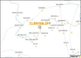
Clarks Bluff (Georgia, United States - USA)Clarks Bluff is a town in the Georgia region of United States - USA. An overview map of the region around Clarks Bluff is displayed below.
regional and 3d topo map of Clarks Bluff, United States - USA ::
Clarks Bluff airports ::
The nearest airport is JAX - Jacksonville Intl, located 50.8 km south of Clarks Bluff.
Other airports nearby include NIP - Jacksonville Nas (79.0 km south), VAD - Valdosta Moody Afb (132.0 km west), SVN - Hunter Aaf (134.5 km north east), SAV - Savannah Hilton Head Intl (143.9 km north east), Nearby towns ::
Tompkins (3.6km south east) //
Jefferson (3.6km north east) //
Hazlehurst (3.9km south west) //
Scarlet (4.6km east) //
Jerusalem (5.4km north west) //
Bullhead Bluff (6.8km south west) //
Midriver (6.7km north west) //
Plantation Point (6.8km east) //
Silco (8.2km south) //
Hopewell (7.5km north east) //
Tarboro (8.7km north) //
Mays Bluff (8.2km south west) //
[all distances 'as the bird flies' and approximate] 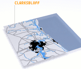 Places with similar names to Clarks Bluff, United States - USA ::
// Clarks Bluff (US)
Disclaimer :: Information on this page comes without warranty of any kind |
||
|
Where is Clarks Bluff? Elevation and coordinates ::
Latitude (lat): 30°56'22"N Longitude (lon): 81°48'42"W
Elevation (approx.): 4m (map arrows pan, magnifying glasses zoom) |
||
|
Visiting Clarks Bluff? Hotel/Accommodation ::
Book a hotel in Clarks Bluff Travel Guide ::
rental cars ::
car rental offers GPS waypoint ::
download a GPX waypoint (PoI) of Clarks Bluff for your GPS receiver
|
||