|
search place name
|
||
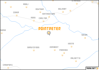
Point Peter (Georgia, United States - USA)Point Peter is a town in the Georgia region of United States - USA. An overview map of the region around Point Peter is displayed below.
regional and 3d topo map of Point Peter, United States - USA ::
Point Peter airports ::
The nearest airport is AND - Andersen Anderson Rgnl, located 62.0 km north east of Point Peter.
Other airports nearby include AGS - Bush Field Augusta Rgnl At Bush Fld (119.5 km south east), ATL - Hartsfield Jackson Atlanta Intl (136.9 km west), MGE - Marietta Dobbins Arb (Atlanta Nas) (139.2 km west), MCN - Macon Middle Georgia Rgnl (156.2 km south), Nearby towns ::
Carlton (5.6km north) //
Veribest (6.0km south) //
Smiths Store (7.0km north) //
Ross (7.4km north west) //
Sandy Cross (7.7km south west) //
Fairview (8.3km south east) //
Enterprise (8.7km south east) //
Vesta (8.2km south east) //
Newtown (9.2km north) //
Oglesby (9.8km north east) //
[all distances 'as the bird flies' and approximate] 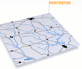 Places with similar names to Point Peter, United States - USA ::
// Point Peter (US)
// Pontepetri (IT)
// Puentepiedra (CO)
// Point Pedro (LK)
// Punta Piedra (HN)
// Puente Piedra (PE)
// Pointe-à-Pitre (GP)
// Puente Piedra (PE)
Disclaimer :: Information on this page comes without warranty of any kind |
||
|
Where is Point Peter? Elevation and coordinates ::
Latitude (lat): 33°59'45"N Longitude (lon): 83°0'48"W
Elevation (approx.): 207m (map arrows pan, magnifying glasses zoom) |
||
|
Visiting Point Peter? Hotel/Accommodation ::
Book a hotel in Point Peter Travel Guide ::
rental cars ::
car rental offers GPS waypoint ::
download a GPX waypoint (PoI) of Point Peter for your GPS receiver
|
||