|
search place name
|
||
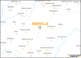
Roopville (Georgia, United States - USA)Roopville is a town in the Georgia region of United States - USA. An overview map of the region around Roopville is displayed below.
regional and 3d topo map of Roopville, United States - USA ::
Roopville airports ::
The nearest airport is ATL - Hartsfield Jackson Atlanta Intl, located 68.3 km east of Roopville.
Other airports nearby include ANB - Anniston Metro (69.1 km west), MGE - Marietta Dobbins Arb (Atlanta Nas) (76.4 km north east), LSF - Fort Benning Lawson Aaf (124.8 km south), BHM - Birmingham Intl (151.2 km west), Nearby towns ::
Star Point (4.3km east) //
Stoney Point (6.0km west) //
Glenloch (6.7km south east) //
Tyus (6.7km west) //
Roosterville (7.7km south west) //
Unity (8.6km south west) //
Oak Grove (8.9km north east) //
Farmers High (10.0km north west) //
Victory (9.6km north west) //
[all distances 'as the bird flies' and approximate] 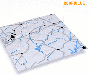
Disclaimer :: Information on this page comes without warranty of any kind |
||
|
Where is Roopville? Elevation and coordinates ::
Latitude (lat): 33°27'23"N Longitude (lon): 85°7'51"W
Elevation (approx.): 380m (map arrows pan, magnifying glasses zoom) |
||
|
Visiting Roopville? Hotel/Accommodation ::
Book a hotel in Roopville Travel Guide ::
rental cars ::
car rental offers GPS waypoint ::
download a GPX waypoint (PoI) of Roopville for your GPS receiver
|
||