|
search place name
|
||
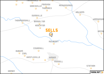
Sells (Georgia, United States - USA)Sells is a town in the Georgia region of United States - USA. An overview map of the region around Sells is displayed below.
regional and 3d topo map of Sells, United States - USA ::
Sells airports ::
The nearest airport is MGE - Marietta Dobbins Arb (Atlanta Nas), located 75.2 km west of Sells.
Other airports nearby include ATL - Hartsfield Jackson Atlanta Intl (80.9 km south west), AND - Andersen Anderson Rgnl (104.7 km north east), MCN - Macon Middle Georgia Rgnl (152.6 km south), WRB - Macon Robins Afb (158.7 km south), Nearby towns ::
Mulberry (2.6km south) //
Hoschton (4.8km north west) //
Braselton (6.0km north west) //
Cedar Hill (6.3km south west) //
Winder (8.3km south) //
Barrow Heights (8.6km south) //
Ednaville (8.2km north west) //
Whistleville (9.9km south west) //
[all distances 'as the bird flies' and approximate] 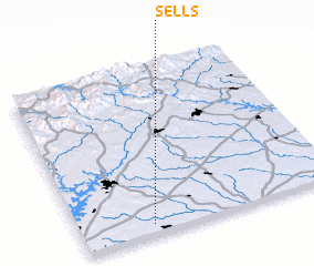 Places with similar names to Sells, United States - USA ::
Disclaimer :: Information on this page comes without warranty of any kind |
||
|
Where is Sells? Elevation and coordinates ::
Latitude (lat): 34°4'1"N Longitude (lon): 83°43'22"W
Elevation (approx.): 239m (map arrows pan, magnifying glasses zoom) |
||
|
Visiting Sells? Hotel/Accommodation ::
Book a hotel in Sells Travel Guide ::
rental cars ::
car rental offers GPS waypoint ::
download a GPX waypoint (PoI) of Sells for your GPS receiver
|
||