|
search place name
|
||
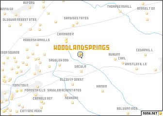
Woodland Springs (Georgia, United States - USA)Woodland Springs is a town in the Georgia region of United States - USA. An overview map of the region around Woodland Springs is displayed below.
regional and 3d topo map of Woodland Springs, United States - USA ::
Woodland Springs airports ::
The nearest airport is MGE - Marietta Dobbins Arb (Atlanta Nas), located 58.3 km west of Woodland Springs.
Other airports nearby include ATL - Hartsfield Jackson Atlanta Intl (64.7 km south west), AND - Andersen Anderson Rgnl (121.6 km north east), MCN - Macon Middle Georgia Rgnl (148.6 km south), WRB - Macon Robins Afb (155.2 km south), Nearby towns ::
Dacula (3.1km south) //
Hog Mountain (4.7km north west) //
Saddlewood (4.5km west) //
Cain Manor (5.3km north west) //
Alcovy Forest (6.4km south) //
Gunter Estates (6.4km west) //
Auburn (6.4km east) //
Timberwood Estates (7.7km north) //
Sardis Estates (8.2km north) //
Somerset Hills (7.1km west) //
Harbin (8.6km south east) //
Saddleback Estates (9.1km south) //
Myrdell Estates (9.7km north west) //
[all distances 'as the bird flies' and approximate] 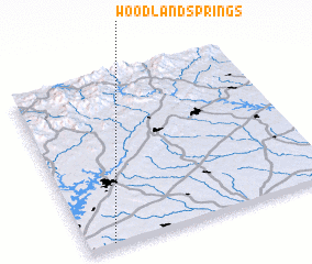 Places with similar names to Woodland Springs, United States - USA :: Disclaimer :: Information on this page comes without warranty of any kind |
||
|
Where is Woodland Springs? Elevation and coordinates ::
Latitude (lat): 34°0'58"N Longitude (lon): 83°53'51"W
Elevation (approx.): 307m (map arrows pan, magnifying glasses zoom) |
||
|
Visiting Woodland Springs? Hotel/Accommodation ::
Book a hotel in Woodland Springs Travel Guide ::
rental cars ::
car rental offers GPS waypoint ::
download a GPX waypoint (PoI) of Woodland Springs for your GPS receiver
|
||