|
search place name
|
||
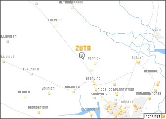
Zuta (Georgia, United States - USA)Zuta is a town in the Georgia region of United States - USA. An overview map of the region around Zuta is displayed below.
regional and 3d topo map of Zuta, United States - USA ::
Zuta airports ::
The nearest airport is SVN - Hunter Aaf, located 87.0 km north east of Zuta.
Other airports nearby include JAX - Jacksonville Intl (92.2 km south), SAV - Savannah Hilton Head Intl (96.5 km north), NIP - Jacksonville Nas (120.6 km south), NBC - Beaufort Mcas (151.9 km north east), Nearby towns ::
Pennick (2.5km east) //
Frazers Crossing (2.9km south east) //
Sterling (5.8km south) //
Brobston (7.2km south) //
Anguilla (7.5km south) //
Pyles Marsh (8.9km south) //
Groveside Park (8.3km south east) //
Everett (9.3km north west) //
Pine Haven (9.9km south east) //
Jamaica (10.0km south west) //
Ridgewood Plantation (10.3km south east) //
[all distances 'as the bird flies' and approximate]  Places with similar names to Zuta, United States - USA ::
Disclaimer :: Information on this page comes without warranty of any kind |
||
|
Where is Zuta? Elevation and coordinates ::
Latitude (lat): 31°19'14"N Longitude (lon): 81°35'3"W
Elevation (approx.): 11m (map arrows pan, magnifying glasses zoom) |
||
|
Visiting Zuta? Hotel/Accommodation ::
Book a hotel in Zuta Travel Guide ::
rental cars ::
car rental offers GPS waypoint ::
download a GPX waypoint (PoI) of Zuta for your GPS receiver
|
||