|
search place name
|
||
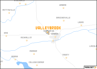
Valley Brook (Indiana, United States - USA)Valley Brook is a town in the Indiana region of United States - USA. An overview map of the region around Valley Brook is displayed below.
regional and 3d topo map of Valley Brook, United States - USA ::
Valley Brook airports ::
The nearest airport is GUS - Peru Grissom Arb, located 31.3 km south west of Valley Brook.
Other airports nearby include IND - Indianapolis Intl (126.8 km south), DAY - James M Cox Dayton Intl (170.6 km south east), FFO - Dayton Wright Patterson Afb (187.4 km south east), MDW - Chicago Midway Intl (193.4 km north west), Nearby towns ::
Sunnymede (0.4km north east) //
Wabash (2.2km south east) //
South Haven (2.8km south east) //
Speicherville (7.0km north east) //
Richvalley (6.8km west) //
Pioneer (8.7km south west) //
[all distances 'as the bird flies' and approximate]  Places with similar names to Valley Brook, United States - USA ::
Disclaimer :: Information on this page comes without warranty of any kind |
||
|
Where is Valley Brook? Elevation and coordinates ::
Latitude (lat): 40°48'20"N Longitude (lon): 85°50'40"W
Elevation (approx.): 238m (map arrows pan, magnifying glasses zoom) |
||
|
Visiting Valley Brook? Hotel/Accommodation ::
Book a hotel in Valley Brook Travel Guide ::
rental cars ::
car rental offers GPS waypoint ::
download a GPX waypoint (PoI) of Valley Brook for your GPS receiver
|
||