|
search place name
|
||
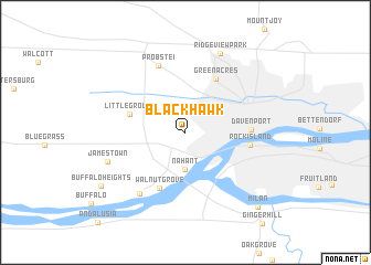
Black Hawk (Iowa, United States - USA)Black Hawk is a town in the Iowa region of United States - USA. An overview map of the region around Black Hawk is displayed below.
regional and 3d topo map of Black Hawk, United States - USA ::
Black Hawk airports ::
The nearest airport is MSN - Madison Dane Co Rgnl Truax Fld, located 209.3 km north east of Black Hawk.
Nearby towns ::
Nahant (3.7km south) //
Little Groves (4.6km north west) //
Walnut Grove (6.0km south) //
Green Acres (5.9km north east) //
Rock Island (5.1km east) //
Davenport (5.0km east) //
Probstei (7.0km north) //
Linwood (7.0km south west) //
Jamestown (6.6km south west) //
Ridgeview Park (8.4km north) //
Buffalo Heights (8.4km south west) //
Milan (9.3km south east) //
[all distances 'as the bird flies' and approximate]  Places with similar names to Black Hawk, United States - USA ::
// Blackhawk (US)
// Black Hawk (US)
// Blackhawk (US)
// Blackhawk (US)
// Blackhawk (US)
// Black Hawk (US)
// Black Hawk (US)
// Black Hawk (US)
// Blackhawk (US)
// Blackhawk (US)
Disclaimer :: Information on this page comes without warranty of any kind |
||
|
Where is Black Hawk? Elevation and coordinates ::
Latitude (lat): 41°31'15"N Longitude (lon): 90°38'15"W
Elevation (approx.): 187m (map arrows pan, magnifying glasses zoom) |
||
|
Visiting Black Hawk? Hotel/Accommodation ::
Book a hotel in Black Hawk Travel Guide ::
rental cars ::
car rental offers GPS waypoint ::
download a GPX waypoint (PoI) of Black Hawk for your GPS receiver
|
||