|
search place name
|
||
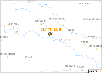
Clay Mills (Iowa, United States - USA)Clay Mills is a town in the Iowa region of United States - USA. An overview map of the region around Clay Mills is displayed below.
regional and 3d topo map of Clay Mills, United States - USA ::
Clay Mills airports ::
The nearest airport is MSN - Madison Dane Co Rgnl Truax Fld, located 169.1 km north east of Clay Mills.
Nearby towns ::
East Canton (4.5km south east) //
Canton (4.5km south east) //
Temple Hill (5.4km north west) //
McGargels Ford (5.7km north) //
Ozark (5.7km east) //
Onslow (10.4km south west) //
[all distances 'as the bird flies' and approximate] 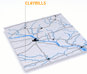 Places with similar names to Clay Mills, United States - USA ::
// Colimillas (MX)
// Kalumbaleza (TZ)
// Kili Mūllazai (PK)
// Calmeilles (FR)
// Colombelles (FR)
// Gauley Mills (US)
Disclaimer :: Information on this page comes without warranty of any kind |
||
|
Where is Clay Mills? Elevation and coordinates ::
Latitude (lat): 42°11'3"N Longitude (lon): 90°56'35"W
Elevation (approx.): 234m (map arrows pan, magnifying glasses zoom) |
||
|
Visiting Clay Mills? Hotel/Accommodation ::
Book a hotel in Clay Mills Travel Guide ::
rental cars ::
car rental offers GPS waypoint ::
download a GPX waypoint (PoI) of Clay Mills for your GPS receiver
|
||