|
search place name
|
||
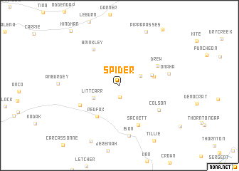
Spider (Kentucky, United States - USA)Spider is a town in the Kentucky region of United States - USA. An overview map of the region around Spider is displayed below.
regional and 3d topo map of Spider, United States - USA ::
Spider airports ::
The nearest airport is TYS - Knoxville Mc Ghee Tyson, located 187.6 km south west of Spider.
Other airports nearby include HKY - Hickory Rgnl (216.7 km south east), LUK - Cincinnati Muni Lunken Fld (243.6 km north west), CVG - Cincinnati Northern Kentucky Intl (251.3 km north west), Nearby towns ::
Bath (1.8km south) //
Pine Top (3.1km north east) //
Littcarr (3.8km south west) //
Nealy (4.3km north east) //
May (4.5km east) //
Redfox (5.6km south west) //
Drew (5.7km north east) //
Brinkley (6.5km north west) //
Sackett (6.7km south) //
Carr Creek (5.8km south west) //
Colson (6.3km south east) //
Isom (8.0km south) //
Omaha (6.5km east) //
Pippa Passes (9.1km north) //
Carbon Glow (9.5km south west) //
Tillie (9.6km south east) //
Hollybush (10.3km north east) //
Hindman (10.5km north west) //
[all distances 'as the bird flies' and approximate] 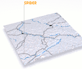 Places with similar names to Spider, United States - USA ::
Disclaimer :: Information on this page comes without warranty of any kind |
||
|
Where is Spider? Elevation and coordinates ::
Latitude (lat): 37°15'31"N Longitude (lon): 82°54'44"W
Elevation (approx.): 324m (map arrows pan, magnifying glasses zoom) |
||
|
Visiting Spider? Hotel/Accommodation ::
Book a hotel in Spider Travel Guide ::
rental cars ::
car rental offers GPS waypoint ::
download a GPX waypoint (PoI) of Spider for your GPS receiver
|
||