|
search place name
|
||
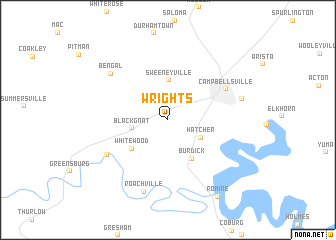
Wrights (Kentucky, United States - USA)Wrights is a town in the Kentucky region of United States - USA. An overview map of the region around Wrights is displayed below.
regional and 3d topo map of Wrights, United States - USA ::
Wrights airports ::
The nearest airport is FTK - Fort Knox Godman Aaf, located 83.1 km north west of Wrights.
Other airports nearby include LOU - Louisville Bowman Fld (104.2 km north), BNA - Nashville Intl (174.4 km south west), CVG - Cincinnati Northern Kentucky Intl (203.1 km north), TYS - Knoxville Mc Ghee Tyson (208.8 km south east), Nearby towns ::
Black Gnat (3.3km west) //
Hatcher (3.6km south east) //
Sweeneyville (4.4km north) //
Burdick (4.8km south east) //
Whitewood (4.5km south west) //
Campbellsville (6.2km north east) //
Bluff Boom (6.6km south west) //
Bengal (7.2km north west) //
Roachville (8.3km south) //
South Campbellsville (7.0km east) //
Romine (9.6km south east) //
[all distances 'as the bird flies' and approximate]  Places with similar names to Wrights, United States - USA ::
Disclaimer :: Information on this page comes without warranty of any kind |
||
|
Where is Wrights? Elevation and coordinates ::
Latitude (lat): 37°18'45"N Longitude (lon): 85°24'0"W
Elevation (approx.): 241m (map arrows pan, magnifying glasses zoom) |
||
|
Visiting Wrights? Hotel/Accommodation ::
Book a hotel in Wrights Travel Guide ::
rental cars ::
car rental offers GPS waypoint ::
download a GPX waypoint (PoI) of Wrights for your GPS receiver
|
||