|
search place name
|
||
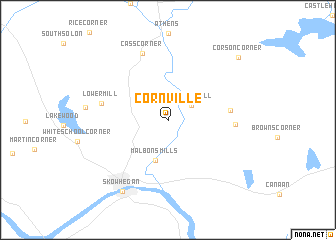
Cornville (Maine, United States - USA)Cornville is a town in the Maine region of United States - USA. An overview map of the region around Cornville is displayed below.
regional and 3d topo map of Cornville, United States - USA ::
Cornville airports ::
The nearest airport is BGR - Bangor Intl, located 66.9 km east of Cornville.
Other airports nearby include PWM - Portland Intl Jetport (141.7 km south), PQI - Northern Maine Rgnl At Presque Isle (241.7 km north east), YQB - Quebec Jean Lesage Intl (255.0 km north west), Nearby towns ::
Waltons Mill (2.5km north east) //
Malbons Mills (4.6km south) //
Gould Corner (5.0km east) //
Mitchell Corner (5.4km east) //
Lower Mill (5.6km west) //
Cass Corner (7.7km north) //
Skowhegan (8.8km south west) //
Corson Corner (8.9km north east) //
[all distances 'as the bird flies' and approximate] 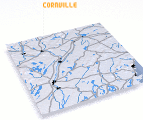 Places with similar names to Cornville, United States - USA ::
// Greenville (US)
// Cornville (US)
// Granville (US)
// Green Valley (US)
// Greenville (US)
// Green Valley (US)
// Green Valley (US)
// Greenville (US)
// Greenville (US)
// Guerneville (US)
Disclaimer :: Information on this page comes without warranty of any kind |
||
|
Where is Cornville? Elevation and coordinates ::
Latitude (lat): 44°50'12"N Longitude (lon): 69°40'25"W
Elevation (approx.): 140m (map arrows pan, magnifying glasses zoom) |
||
|
Visiting Cornville? Hotel/Accommodation ::
Book a hotel in Cornville Travel Guide ::
rental cars ::
car rental offers GPS waypoint ::
download a GPX waypoint (PoI) of Cornville for your GPS receiver
|
||