|
search place name
|
||
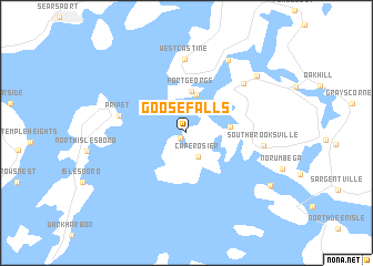
Goose Falls (Maine, United States - USA)Goose Falls is a town in the Maine region of United States - USA. An overview map of the region around Goose Falls is displayed below.
regional and 3d topo map of Goose Falls, United States - USA ::
Goose Falls airports ::
The nearest airport is BGR - Bangor Intl, located 50.5 km north of Goose Falls.
Other airports nearby include PWM - Portland Intl Jetport (143.6 km south west), Nearby towns ::
Harborside (0.6km south west) //
Cape Rosier (2.6km south) //
Castine (3.9km north) //
Fort George (4.2km north) //
Flat Landing (3.2km east) //
Pripet (5.1km west) //
West Castine (7.4km north) //
West Brooksville (6.5km north east) //
South Brooksville (5.7km east) //
North Castine (7.9km north) //
Stover Corner (7.7km north east) //
Eggemoggin (8.0km south east) //
[all distances 'as the bird flies' and approximate] 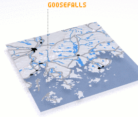 Places with similar names to Goose Falls, United States - USA ::
// Casavells (ES)
Disclaimer :: Information on this page comes without warranty of any kind |
||
|
Where is Goose Falls? Elevation and coordinates ::
Latitude (lat): 44°21'12"N Longitude (lon): 68°48'36"W
Elevation (approx.): 13m (map arrows pan, magnifying glasses zoom) |
||
|
Visiting Goose Falls? Hotel/Accommodation ::
Book a hotel in Goose Falls Travel Guide ::
rental cars ::
car rental offers GPS waypoint ::
download a GPX waypoint (PoI) of Goose Falls for your GPS receiver
|
||