|
search place name
|
||
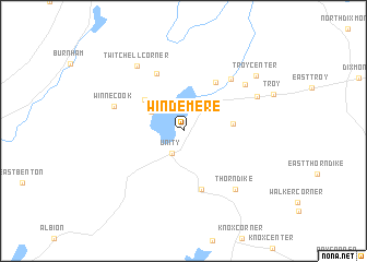
Windemere (Maine, United States - USA)Windemere is a town in the Maine region of United States - USA. An overview map of the region around Windemere is displayed below.
regional and 3d topo map of Windemere, United States - USA ::
Windemere airports ::
The nearest airport is BGR - Bangor Intl, located 43.9 km north east of Windemere.
Other airports nearby include PWM - Portland Intl Jetport (134.9 km south west), Nearby towns ::
Unity (2.4km south) //
Oakwood (3.1km north west) //
Greens Corner (3.8km north east) //
Reynolds Corner (4.3km north west) //
Gerrish Corner (3.7km east) //
Smarts Corner (5.5km north east) //
Farwells Corner (6.2km south) //
Dodge Corner (6.1km north) //
Cooks Corner (6.3km north east) //
Winnecook (5.7km north west) //
Mitchell Corner (6.5km north east) //
Thorndike (7.0km south east) //
Twitchell Corner (7.5km north west) //
Hales Corner (6.4km north east) //
Troy Center (7.8km north east) //
[all distances 'as the bird flies' and approximate]  Places with similar names to Windemere, United States - USA ::
Disclaimer :: Information on this page comes without warranty of any kind |
||
|
Where is Windemere? Elevation and coordinates ::
Latitude (lat): 44°37'53"N Longitude (lon): 69°19'28"W
Elevation (approx.): 51m (map arrows pan, magnifying glasses zoom) |
||
|
Visiting Windemere? Hotel/Accommodation ::
Book a hotel in Windemere Travel Guide ::
rental cars ::
car rental offers GPS waypoint ::
download a GPX waypoint (PoI) of Windemere for your GPS receiver
|
||