|
search place name
|
||
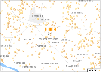
Kinna (Maryland, United States - USA)Kinna is a town in the Maryland region of United States - USA. An overview map of the region around Kinna is displayed below.
regional and 3d topo map of Kinna, United States - USA ::
Kinna airports ::
The nearest airport is IAD - Washington Dulles Intl, located 46.5 km south of Kinna.
Other airports nearby include DCA - Ronald Reagan Washington Natl (63.0 km south east), BWI - Baltimore Washington Intl (63.8 km east), ADW - Camp Springs Andrews Afb (Washington Dc Naf) (74.7 km south east), APG - Aberdeen Phillips Aaf (104.1 km east), Nearby towns ::
Reels Mill (0.4km north) //
Kidwiler Park (1.1km west) //
Riverwood (1.1km east) //
Araby View (1.5km west) //
Double Tree Estates (2.3km north) //
Stone Barn Station (2.3km south) //
Frederick Junction (2.3km north west) //
Reichs Ford Estates (2.7km north) //
Aylor (2.9km north) //
Hines Woods (2.8km north east) //
South Covell (3.4km south west) //
Urbana Overlook (4.0km south) //
Urbana (3.8km south east) //
Hope Hill (3.6km south west) //
Bartonsville (4.0km north) //
Pine Cliff (4.2km north) //
Country Squire (3.9km north east) //
Hillmark (4.3km north) //
Windy Hill (4.6km north) //
Clear View (4.8km north) //
Centerville (4.1km south east) //
Hope Valley Hills (4.9km south west) //
Tulip Hill (5.1km north) //
Ijamsville (4.0km east) //
Spring Ridge (5.1km north) //
Sugarloaf Estates (5.3km south) //
Olacin (5.4km north) //
Ijamsville Heights (4.2km east) //
Grove (5.2km north west) //
[all distances 'as the bird flies' and approximate]  Places with similar names to Kinna, United States - USA ::
Disclaimer :: Information on this page comes without warranty of any kind |
||
|
Where is Kinna? Elevation and coordinates ::
Latitude (lat): 39°21'27"N Longitude (lon): 77°22'10"W
Elevation (approx.): 112m (map arrows pan, magnifying glasses zoom) |
||
|
Visiting Kinna? Hotel/Accommodation ::
Book a hotel in Kinna Travel Guide ::
rental cars ::
car rental offers GPS waypoint ::
download a GPX waypoint (PoI) of Kinna for your GPS receiver
|
||