|
search place name
|
||
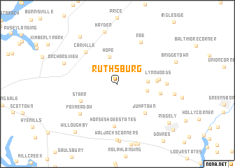
Ruthsburg (Maryland, United States - USA)Ruthsburg is a town in the Maryland region of United States - USA. An overview map of the region around Ruthsburg is displayed below.
regional and 3d topo map of Ruthsburg, United States - USA ::
Ruthsburg airports ::
The nearest airport is DOV - Dover Afb, located 44.9 km east of Ruthsburg.
Other airports nearby include APG - Aberdeen Phillips Aaf (54.5 km north), BWI - Baltimore Washington Intl (64.3 km west), ILG - Wilmington New Castle (80.9 km north), ADW - Camp Springs Andrews Afb (Washington Dc Naf) (81.7 km west), Nearby towns ::
Hope (4.4km north) //
Fox Field (3.8km east) //
Deans Meadows (3.8km east) //
Lyn Woods (5.0km east) //
Jumptown (5.8km south east) //
Starr (5.3km south west) //
Lynn Woods (5.2km east) //
Horseshoe Estates (6.7km south) //
Buckels Corner (5.5km east) //
Carville (6.5km north west) //
Roe (7.2km north east) //
Fox Meadow (6.7km south west) //
The Plains (6.1km east) //
Hayden (8.5km north) //
Waljacks Corners (8.9km south) //
Orchard View (7.4km north west) //
Tall Timbers Estates (8.8km north west) //
Willoughby (9.3km south west) //
Ridgely (8.8km south east) //
Trinity (10.0km south east) //
[all distances 'as the bird flies' and approximate]  Places with similar names to Ruthsburg, United States - USA ::
// Rathsberg (DE)
Disclaimer :: Information on this page comes without warranty of any kind |
||
|
Where is Ruthsburg? Elevation and coordinates ::
Latitude (lat): 39°0'11"N Longitude (lon): 75°57'30"W
Elevation (approx.): 24m (map arrows pan, magnifying glasses zoom) |
||
|
Visiting Ruthsburg? Hotel/Accommodation ::
Book a hotel in Ruthsburg Travel Guide ::
rental cars ::
car rental offers GPS waypoint ::
download a GPX waypoint (PoI) of Ruthsburg for your GPS receiver
|
||