|
search place name
|
||
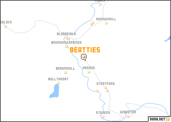
Beatties (New Hampshire, United States - USA)Beatties is a town in the New Hampshire region of United States - USA. An overview map of the region around Beatties is displayed below.
regional and 3d topo map of Beatties, United States - USA ::
Beatties airports ::
The nearest airport is YSC - Sherbrooke, located 81.6 km north of Beatties.
Other airports nearby include BTV - Burlington Intl (126.5 km west), YJN - St. Jean St Jean (148.0 km north west), PWM - Portland Intl Jetport (156.5 km south east), YHU - Montreal St Hubert (169.2 km north west), Nearby towns ::
Masons (2.5km south) //
Browns Mill (4.0km south west) //
Brunswick Springs (4.3km north west) //
North Stratford (5.6km north west) //
Bloomfield (5.9km north west) //
Maidstone (6.8km south) //
Stratford (6.6km south east) //
Bullthroat (6.5km south west) //
Mapleton (7.4km south east) //
Tinkerville (8.1km north) //
Georges (8.5km north) //
Meriden Hill (8.9km north) //
[all distances 'as the bird flies' and approximate] 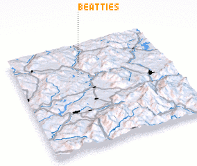 Places with similar names to Beatties, United States - USA ::
Disclaimer :: Information on this page comes without warranty of any kind |
||
|
Where is Beatties? Elevation and coordinates ::
Latitude (lat): 44°42'28"N Longitude (lon): 71°35'43"W
Elevation (approx.): 293m (map arrows pan, magnifying glasses zoom) |
||
|
Visiting Beatties? Hotel/Accommodation ::
Book a hotel in Beatties Travel Guide ::
rental cars ::
car rental offers GPS waypoint ::
download a GPX waypoint (PoI) of Beatties for your GPS receiver
|
||