|
search place name
|
||
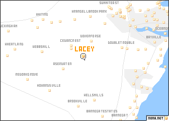
Lacey (New Jersey, United States - USA)Lacey is a town in the New Jersey region of United States - USA. An overview map of the region around Lacey is displayed below.
regional and 3d topo map of Lacey, United States - USA ::
Lacey airports ::
The nearest airport is NEL - Lakehurst Naes, located 18.5 km north of Lacey.
Other airports nearby include WRI - Wrightstown Mc Guire Afb (29.9 km north west), ACY - Atlantic City Intl (52.0 km south west), TTN - Trenton Mercer (63.0 km north west), PHL - Philadelphia Intl (80.9 km west), Nearby towns ::
Camp Columbus (3.4km north west) //
Cedar Crest (4.1km north west) //
Dover Forge (4.4km north) //
Aserdaten (4.1km south west) //
Double Trouble (6.9km north east) //
Wells Mills (8.9km south) //
Holiday Heights (8.9km north east) //
Howardsville (8.9km south west) //
Keswick Grove (9.6km north west) //
Crestwood Village (10.1km north west) //
[all distances 'as the bird flies' and approximate]  Places with similar names to Lacey, United States - USA ::
Disclaimer :: Information on this page comes without warranty of any kind |
||
|
Where is Lacey? Elevation and coordinates ::
Latitude (lat): 39°52'21"N Longitude (lon): 74°17'44"W
Elevation (approx.): 35m (map arrows pan, magnifying glasses zoom) |
||
|
Visiting Lacey? Hotel/Accommodation ::
Book a hotel in Lacey Travel Guide ::
rental cars ::
car rental offers GPS waypoint ::
download a GPX waypoint (PoI) of Lacey for your GPS receiver
|
||