|
search place name
|
||
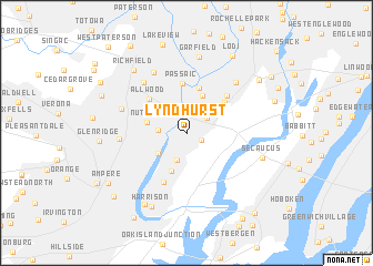
Lyndhurst (New Jersey, United States - USA)Lyndhurst is a town in the New Jersey region of United States - USA. An overview map of the region around Lyndhurst is displayed below.
regional and 3d topo map of Lyndhurst, United States - USA ::
Lyndhurst airports ::
The nearest airport is TEB - Teterboro, located 6.9 km north east of Lyndhurst.
Other airports nearby include EWR - Newark Liberty Intl (13.8 km south), LGA - New York La Guardia (21.6 km east), JFK - New York John F Kennedy Intl (34.9 km south east), HPN - White Plains Westchester Co (45.1 km north east), Nearby towns ::
Kingsland (1.3km south east) //
Rutherford (2.2km north east) //
Delawanna (2.3km north west) //
North Arlington (2.7km south) //
Avondale (2.2km west) //
Belleville (3.0km south west) //
East Rutherford (3.3km north east) //
Nutley (3.2km west) //
Carlton Hill (4.0km north) //
Arlington (4.0km south) //
Wallington (4.7km north) //
Carlstadt (4.2km north east) //
Passaic (5.0km north) //
Allwood (4.5km north west) //
Kearny (5.2km south) //
Wood-Ridge (4.8km north east) //
Clifton (6.1km north west) //
Bloomfield (5.2km west) //
Athenia (6.6km north west) //
Brookdale (5.5km north west) //
Hasbrouck Heights (6.3km north east) //
Garfield (7.8km north) //
Secaucus (6.2km south east) //
Harrison (7.8km south) //
East Newark (7.7km south west) //
Richfield (7.5km north west) //
Glen Ridge (6.7km west) //
Teterboro (7.6km north east) //
Lodi (8.5km north east) //
[all distances 'as the bird flies' and approximate]  Places with similar names to Lyndhurst, United States - USA ::
Disclaimer :: Information on this page comes without warranty of any kind |
||
|
Where is Lyndhurst? Elevation and coordinates ::
Latitude (lat): 40°48'43"N Longitude (lon): 74°7'29"W
Elevation (approx.): 11m (map arrows pan, magnifying glasses zoom) |
||
|
Visiting Lyndhurst? Hotel/Accommodation ::
Book a hotel in Lyndhurst Travel Guide ::
rental cars ::
car rental offers GPS waypoint ::
download a GPX waypoint (PoI) of Lyndhurst for your GPS receiver
|
||