|
search place name
|
||
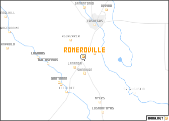
Romeroville (New Mexico, United States - USA)Romeroville is a town in the New Mexico region of United States - USA. An overview map of the region around Romeroville is displayed below.
regional and 3d topo map of Romeroville, United States - USA ::
Romeroville airports ::
The nearest airport is ABQ - Albuquerque Intl Sunport (Kirtland Afb), located 135.2 km south west of Romeroville.
Other airports nearby include TCC - Tucumcari Muni (153.9 km east), CVS - Clovis Cannon Afb (216.4 km south east), Nearby towns ::
La Manga (2.3km south west) //
Ojita (2.7km south) //
Romero (2.4km north east) //
Sheridan (3.0km south) //
Agua Zarca (5.1km north west) //
Gabaldon (6.8km south west) //
Santa Ana (6.7km south west) //
Tecolote (7.7km south west) //
Ojitos Frios (6.6km west) //
Las Vegas (8.1km north) //
[all distances 'as the bird flies' and approximate] 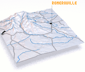 Places with similar names to Romeroville, United States - USA ::
// Réméréville (FR)
Disclaimer :: Information on this page comes without warranty of any kind |
||
|
Where is Romeroville? Elevation and coordinates ::
Latitude (lat): 35°31'22"N Longitude (lon): 105°14'39"W
Elevation (approx.): 1941m (map arrows pan, magnifying glasses zoom) |
||
|
Visiting Romeroville? Hotel/Accommodation ::
Book a hotel in Romeroville Travel Guide ::
rental cars ::
car rental offers GPS waypoint ::
download a GPX waypoint (PoI) of Romeroville for your GPS receiver
|
||