|
search place name
|
||
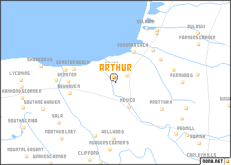
Arthur (New York, United States - USA)Arthur is a town in the New York region of United States - USA. An overview map of the region around Arthur is displayed below.
regional and 3d topo map of Arthur, United States - USA ::
Arthur airports ::
The nearest airport is SYR - Syracuse Hancock Intl, located 44.2 km south of Arthur.
Other airports nearby include ART - Watertown Intl (58.2 km north), GTB - Fort Drum Wheeler Sack Aaf (75.5 km north east), YGK - Kingston (85.8 km north), ROC - Greater Rochester Intl (122.9 km west), Nearby towns ::
Texas (2.0km north) //
North Church Corner (1.7km north east) //
Mexico (4.2km south) //
Ramona Beach (5.4km north east) //
Demster Beach (5.4km north west) //
Demster (5.6km west) //
New Haven (5.7km west) //
Daysville Corner (6.8km north east) //
Daysville (6.5km north east) //
Hickory Grove (6.2km west) //
Prattham (7.0km south east) //
Vermilion (9.0km south) //
Selkirk (9.5km north east) //
Port Ontario (9.3km north east) //
Bethel Corners (9.9km north east) //
[all distances 'as the bird flies' and approximate] 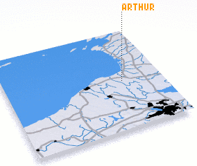 Places with similar names to Arthur, United States - USA ::
Disclaimer :: Information on this page comes without warranty of any kind |
||
|
Where is Arthur? Elevation and coordinates ::
Latitude (lat): 43°29'42"N Longitude (lon): 76°14'54"W
Elevation (approx.): 103m (map arrows pan, magnifying glasses zoom) |
||
|
Visiting Arthur? Hotel/Accommodation ::
Book a hotel in Arthur Travel Guide ::
rental cars ::
car rental offers GPS waypoint ::
download a GPX waypoint (PoI) of Arthur for your GPS receiver
|
||