|
search place name
|
||
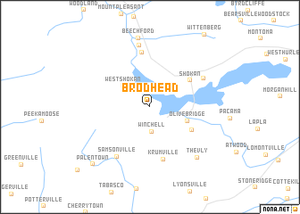
Brodhead (New York, United States - USA)Brodhead is a town in the New York region of United States - USA. An overview map of the region around Brodhead is displayed below.
regional and 3d topo map of Brodhead, United States - USA ::
Brodhead airports ::
The nearest airport is SWF - Newburgh Stewart Intl, located 50.4 km south of Brodhead.
Other airports nearby include ALB - Albany Intl (97.0 km north east), HPN - White Plains Westchester Co (107.7 km south east), TEB - Teterboro (122.6 km south), BDR - Stratford Igor I Sikorsky Mem (128.1 km south east), Nearby towns ::
Winchell (3.1km south) //
West Shokan (3.6km north west) //
Olivebridge (3.9km south east) //
Davis Corners (4.8km south east) //
Shokan (5.0km north east) //
Krumville (6.7km south) //
Boiceville (6.9km north) //
Samsonville (6.9km south west) //
Ashokan (6.1km north east) //
Cold Brook (7.8km north) //
The Vly (7.7km south east) //
Beechford (8.7km north) //
Palentown (8.9km south west) //
[all distances 'as the bird flies' and approximate]  Places with similar names to Brodhead, United States - USA ::
Disclaimer :: Information on this page comes without warranty of any kind |
||
|
Where is Brodhead? Elevation and coordinates ::
Latitude (lat): 41°56'37"N Longitude (lon): 74°15'28"W
Elevation (approx.): 217m (map arrows pan, magnifying glasses zoom) |
||
|
Visiting Brodhead? Hotel/Accommodation ::
Book a hotel in Brodhead Travel Guide ::
rental cars ::
car rental offers GPS waypoint ::
download a GPX waypoint (PoI) of Brodhead for your GPS receiver
|
||