|
search place name
|
||
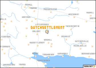
Dutch Settlement (New York, United States - USA)Dutch Settlement is a town in the New York region of United States - USA. An overview map of the region around Dutch Settlement is displayed below.
regional and 3d topo map of Dutch Settlement, United States - USA ::
Dutch Settlement airports ::
The nearest airport is SYR - Syracuse Hancock Intl, located 23.8 km south of Dutch Settlement.
Other airports nearby include ART - Watertown Intl (74.3 km north), GTB - Fort Drum Wheeler Sack Aaf (86.2 km north), YGK - Kingston (108.5 km north), ROC - Greater Rochester Intl (131.6 km west), Nearby towns ::
Little France (3.0km north west) //
Whig Hill (3.4km south) //
Union Settlement (2.8km east) //
Gulf Bridge (3.9km south) //
Mallory (3.2km west) //
West Monroe (4.9km south) //
Mud Settlement (5.4km south west) //
Gayville (5.6km east) //
Carley Mills (7.0km north west) //
Morse (6.8km north west) //
Bardeen Corners (6.5km west) //
Hastings Center (6.3km west) //
Parish Center (8.6km north) //
Central Square (7.0km south west) //
Big Bay (9.4km south) //
Hastings (8.2km north west) //
Constantia (10.6km south east) //
[all distances 'as the bird flies' and approximate] 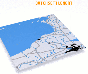 Places with similar names to Dutch Settlement, United States - USA ::
// Dutch Settlement (US)
// Dutch Settlement (US)
Disclaimer :: Information on this page comes without warranty of any kind |
||
|
Where is Dutch Settlement? Elevation and coordinates ::
Latitude (lat): 43°19'28"N Longitude (lon): 76°4'40"W
Elevation (approx.): 162m (map arrows pan, magnifying glasses zoom) |
||
|
Visiting Dutch Settlement? Hotel/Accommodation ::
Book a hotel in Dutch Settlement Travel Guide ::
rental cars ::
car rental offers GPS waypoint ::
download a GPX waypoint (PoI) of Dutch Settlement for your GPS receiver
|
||