|
search place name
|
||
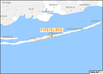
Fire Island (New York, United States - USA)Fire Island is a town in the New York region of United States - USA. An overview map of the region around Fire Island is displayed below.
regional and 3d topo map of Fire Island, United States - USA ::
Fire Island airports ::
The nearest airport is ISP - Islip Long Island Mac Arthur, located 16.9 km north of Fire Island.
Other airports nearby include JFK - New York John F Kennedy Intl (53.5 km west), BDR - Stratford Igor I Sikorsky Mem (57.3 km north), LGA - New York La Guardia (63.0 km west), HPN - White Plains Westchester Co (66.4 km north west), Nearby towns ::
Seaview (0.3km west) //
Ocean Bay Park (0.5km east) //
Ocean Beach (0.9km west) //
Point o'Woods (1.5km east) //
Robbins Rest (1.6km west) //
Atlantique (2.2km west) //
Lonelyville (2.5km west) //
Fair Harbor (3.4km west) //
Saltaire (4.5km west) //
Cherry Grove (5.0km east) //
Kismet (5.1km west) //
Great River (8.2km north) //
Fire Island Pines (6.9km east) //
[all distances 'as the bird flies' and approximate]  Places with similar names to Fire Island, United States - USA ::
// Forsland (NO)
// Forsland (NO)
// Forsland (NO)
// Frøysland (NO)
// Versland (NO)
// Vriesland (US)
// Friesland (US)
// Varzelândia (BR)
// Fair Island (CA)
// Friesland (US)
Disclaimer :: Information on this page comes without warranty of any kind |
||
|
Where is Fire Island? Elevation and coordinates ::
Latitude (lat): 40°38'51"N Longitude (lon): 73°8'47"W
Elevation (approx.): 5m (map arrows pan, magnifying glasses zoom) |
||
|
Visiting Fire Island? Hotel/Accommodation ::
Book a hotel in Fire Island Travel Guide ::
rental cars ::
car rental offers GPS waypoint ::
download a GPX waypoint (PoI) of Fire Island for your GPS receiver
|
||