|
search place name
|
||
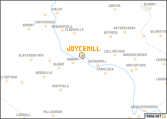
Joyce Mill (North Carolina, United States - USA)Joyce Mill is a town in the North Carolina region of United States - USA. An overview map of the region around Joyce Mill is displayed below.
regional and 3d topo map of Joyce Mill, United States - USA ::
Joyce Mill airports ::
The nearest airport is INT - Winston-salem Smith Reynolds, located 47.5 km south of Joyce Mill.
Other airports nearby include HKY - Hickory Rgnl (125.4 km south west), CLT - Charlotte Douglas Intl (154.7 km south), RDU - Raleigh-durham Raleigh Durham Intl (162.4 km south east), POB - Fayetteville Pope Afb (196.6 km south east), Nearby towns ::
Asbury (2.1km south west) //
Jessup Mill (2.9km south east) //
Albion (4.8km south west) //
Francisco (5.0km south east) //
Claudville (6.1km north) //
Collinstown (5.7km east) //
Mount Herman (6.1km west) //
Dry Pond (7.2km north east) //
Meadowfield (7.6km north west) //
Westfield (8.0km south west) //
Woodville (8.1km south west) //
Carters Mill (10.2km north west) //
[all distances 'as the bird flies' and approximate]  Places with similar names to Joyce Mill, United States - USA ::
// Geçimli (TR)
// Geçimli (TR)
// Geçimli (TR)
// Geçimli (TR)
// Jiāsimulia (BD)
// Gesimbala (CF)
// Gisamolo (PG)
// Gissamåla (SE)
// Gissemåla (SE)
// Jai Sambálô (GW)
Disclaimer :: Information on this page comes without warranty of any kind |
||
|
Where is Joyce Mill? Elevation and coordinates ::
Latitude (lat): 36°32'12"N Longitude (lon): 80°24'1"W
Elevation (approx.): 344m (map arrows pan, magnifying glasses zoom) |
||
|
Visiting Joyce Mill? Hotel/Accommodation ::
Book a hotel in Joyce Mill Travel Guide ::
rental cars ::
car rental offers GPS waypoint ::
download a GPX waypoint (PoI) of Joyce Mill for your GPS receiver
|
||