|
search place name
|
||
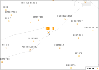
Irwin (Ohio, United States - USA)Irwin is a town in the Ohio region of United States - USA. An overview map of the region around Irwin is displayed below.
regional and 3d topo map of Irwin, United States - USA ::
Irwin airports ::
The nearest airport is CMH - Port Columbus Intl, located 52.8 km east of Irwin.
Other airports nearby include FFO - Dayton Wright Patterson Afb (58.0 km south west), LCK - Columbus Rickenbacker Intl (59.0 km south east), DAY - James M Cox Dayton Intl (66.9 km west), LUK - Cincinnati Muni Lunken Fld (138.5 km south west), Nearby towns ::
Rosedale (5.7km south east) //
Five Points (5.2km south west) //
Woodstock (6.6km north west) //
Fountain Park (7.3km north west) //
Milford Center (7.7km north east) //
Mechanicsburg (8.0km south west) //
[all distances 'as the bird flies' and approximate] 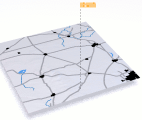 Places with similar names to Irwin, United States - USA ::
Disclaimer :: Information on this page comes without warranty of any kind |
||
|
Where is Irwin? Elevation and coordinates ::
Latitude (lat): 40°7'21"N Longitude (lon): 83°29'22"W
Elevation (approx.): 307m (map arrows pan, magnifying glasses zoom) |
||
|
Visiting Irwin? Hotel/Accommodation ::
Book a hotel in Irwin Travel Guide ::
rental cars ::
car rental offers GPS waypoint ::
download a GPX waypoint (PoI) of Irwin for your GPS receiver
|
||