|
search place name
|
||
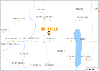
Oakfield (Ohio, United States - USA)Oakfield is a town in the Ohio region of United States - USA. An overview map of the region around Oakfield is displayed below.
regional and 3d topo map of Oakfield, United States - USA ::
Oakfield airports ::
The nearest airport is YNG - Youngstown Warren Rgnl, located 21.8 km south east of Oakfield.
Other airports nearby include AKR - Akron Fulton Intl (66.2 km south west), CLE - Cleveland Hopkins Intl (83.6 km west), PIT - Pittsburgh (pennsylva) Pittsburgh Intl (114.4 km south east), YXU - London (182.4 km north), Nearby towns ::
Spokane (2.1km south) //
North Bristol (1.6km west) //
Deacon Creek Corner (2.3km south east) //
Bristolville (2.9km south west) //
Lockwood (5.8km north) //
North Bloomfield (6.3km north) //
East Farmington (5.7km west) //
Wildare (7.4km south east) //
West Mecca (6.5km east) //
Clover Hill (9.2km north) //
Klondike (10.6km south east) //
[all distances 'as the bird flies' and approximate] 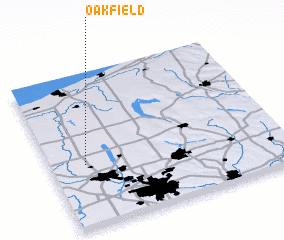 Places with similar names to Oakfield, United States - USA ::
Disclaimer :: Information on this page comes without warranty of any kind |
||
|
Where is Oakfield? Elevation and coordinates ::
Latitude (lat): 41°24'32"N Longitude (lon): 80°51'0"W
Elevation (approx.): 283m (map arrows pan, magnifying glasses zoom) |
||
|
Visiting Oakfield? Hotel/Accommodation ::
Book a hotel in Oakfield Travel Guide ::
rental cars ::
car rental offers GPS waypoint ::
download a GPX waypoint (PoI) of Oakfield for your GPS receiver
|
||