|
search place name
|
||
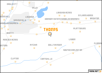
Thorps (Ohio, United States - USA)Thorps is a town in the Ohio region of United States - USA. An overview map of the region around Thorps is displayed below.
regional and 3d topo map of Thorps, United States - USA ::
Thorps airports ::
The nearest airport is FFO - Dayton Wright Patterson Afb, located 29.8 km west of Thorps.
Other airports nearby include DAY - James M Cox Dayton Intl (43.9 km west), LCK - Columbus Rickenbacker Intl (67.1 km east), CMH - Port Columbus Intl (70.9 km east), LUK - Cincinnati Muni Lunken Fld (105.7 km south west), Nearby towns ::
Dolly Varden (4.4km south) //
Harmony (4.8km north) //
Cherry Point Mobile Home Park (4.5km north west) //
Locustgrove (4.1km west) //
Harmony Estates Mobile Home Park (6.2km north east) //
Holiday Hills (6.6km north west) //
Pitchin (6.3km south west) //
Crawford Mobile Home Park (6.8km north east) //
Shoups Mobile Home Park (7.1km north west) //
Lisbon (6.5km east) //
Brookside Park Mobile Home Park (8.1km north) //
Bon Air Mobile Home Park (7.7km north west) //
Hollandia View (7.4km north east) //
Lakeview Acres (8.5km north east) //
Lagonda (8.5km north west) //
South Charleston (8.7km south east) //
[all distances 'as the bird flies' and approximate] 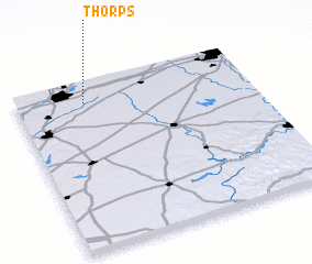 Places with similar names to Thorps, United States - USA :: Disclaimer :: Information on this page comes without warranty of any kind |
||
|
Where is Thorps? Elevation and coordinates ::
Latitude (lat): 39°52'48"N Longitude (lon): 83°42'26"W
Elevation (approx.): 334m (map arrows pan, magnifying glasses zoom) |
||
|
Visiting Thorps? Hotel/Accommodation ::
Book a hotel in Thorps Travel Guide ::
rental cars ::
car rental offers GPS waypoint ::
download a GPX waypoint (PoI) of Thorps for your GPS receiver
|
||