|
search place name
|
||
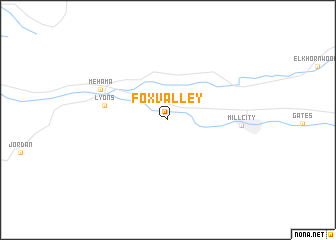
Fox Valley (Oregon, United States - USA)Fox Valley is a town in the Oregon region of United States - USA. An overview map of the region around Fox Valley is displayed below.
regional and 3d topo map of Fox Valley, United States - USA ::
Fox Valley airports ::
The nearest airport is MMV - Mackminnville Mc Minnville Muni, located 66.8 km north west of Fox Valley.
Other airports nearby include PDX - Portland Intl (92.2 km north), Nearby towns ::
 Places with similar names to Fox Valley, United States - USA ::
// Foxville (US)
// Foxville (US)
// Foxvale (US)
// Vicksville (US)
// Fox Valley (US)
// Foxville (US)
// Foxville (US)
// Vicksville (US)
// Vicksville (KY)
// Vieux-Viel (FR)
Disclaimer :: Information on this page comes without warranty of any kind |
||
|
Where is Fox Valley? Elevation and coordinates ::
Latitude (lat): 44°45'35"N Longitude (lon): 122°33'2"W
Elevation (approx.): 238m (map arrows pan, magnifying glasses zoom) |
||
|
Visiting Fox Valley? Hotel/Accommodation ::
Book a hotel in Fox Valley Travel Guide ::
rental cars ::
car rental offers GPS waypoint ::
download a GPX waypoint (PoI) of Fox Valley for your GPS receiver
|
||